Kurilpa – Water, Water, Everywhere
Have you ever wondered what it means to live on a floodplain? Why do certain streets, hundreds of metres inland from the river, repeatedly flood?
Local historian Paul Granville’s has lived in Highgate Hill for over 35 years. His research maps the tapestry of watercourses, swamps and creeks upon which we dwell. As well as the history of trying to tame and drain them over the past 100 plus years.
Read the full article, originally published on Paul’s blog Highgate Hill and Its History on 6 February 2021.
The geography of Kurilpa
Image: openstreetmap annotated by P. Granville.
The location of watercourses and swamps on the Kurilpa peninsula as shown on various maps produced between 1844 and 1865, plotted on a modern street map. The locations are derived from numerous early maps, descriptions and from my observations.
The Kurilpa peninsula, encompassing South Brisbane, West End and Highgate Hill, is named for the fawn-footed melomy called the “corril” or “kuril” in various South Eastern Queensland languages. Covered by extensive wetlands, Kurilpa was a source of both food and drinking water.
After European settlement, the Kurilpa area went through a period in which the wetlands were polluted and expensive drainage works were undertaken while ironically there were frequent shortages of water for household use.
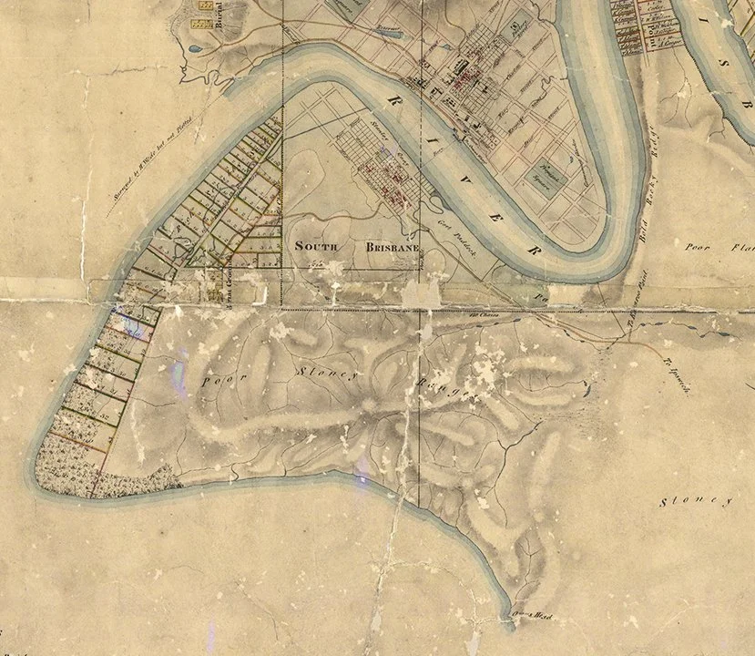
Extract from Henry Wade’s 1844 Map of Brisbane (Queensland State Archives).
This map, produced by Henry Wade in 1844, shows clearly the ridges along the paths of today’s Dornoch Terrace, Gladstone Road, and Hardgrave Road.
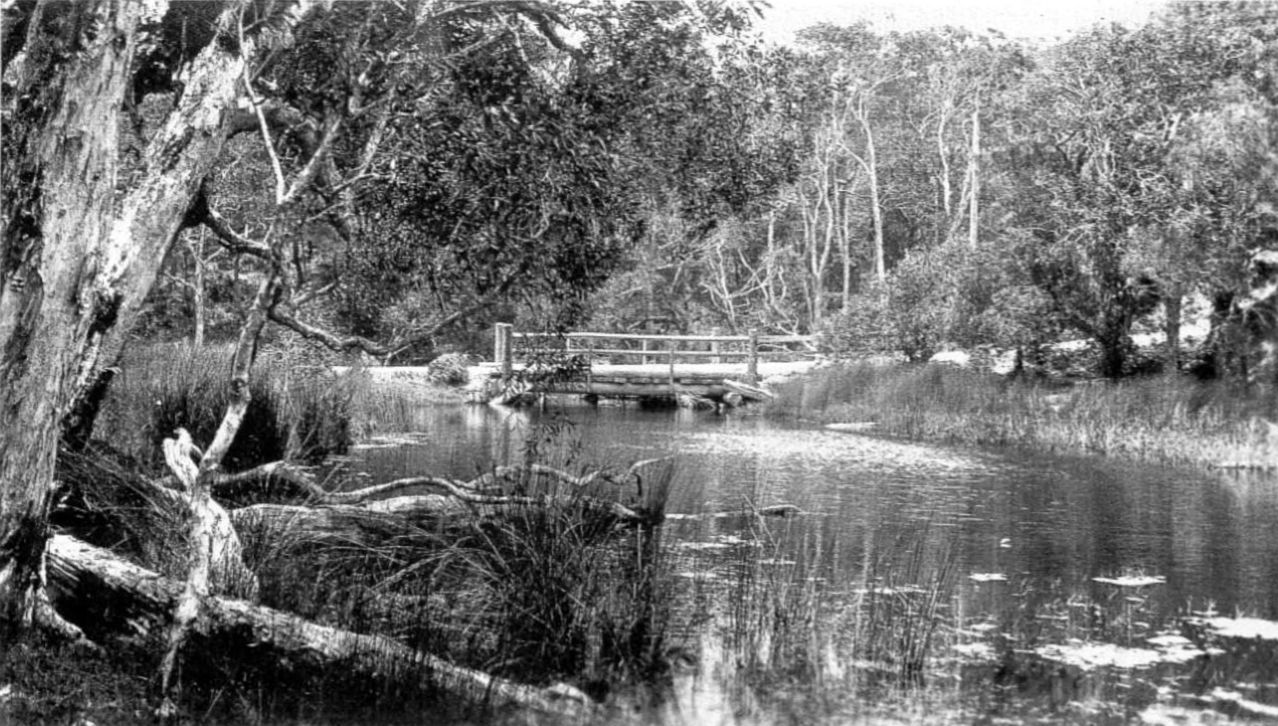
From these ridges, creeks flowed in various directions, including to wetlands between Montague Road and the river, along Melbourne Street and in the Woolloongabba area.
Image: Creek and Bridge at Clarence Corner Woolloongabba (from Memories along the Boggo Track by Annie Mackenzie).
A significant feature was a tidal creek which flowed into the river near the location of the Southbank lagoon and drained a swamp which extended down Merivale Street and into Melbourne Street.
Image: The South Brisbane Creek which flowed from a swamp near Melbourne Street. Extract from Bailey’s map of 1862. Queensland State Archive.
After rain, numerous creeks on the south side of the peninsula ran straight to the river. There are remnants in, for example, Dauphin Terrace, Derby Street and Roseberry Street Parks.


Watercourses
A few historic images show these watercourses. In the one below, looking towards West End from Dornoch Terrace, the upper part of a creek is visible snaking down the hill between houses and passing under a small wooden bridge on Boundary Street. This area near today’s Baynes Street was known as “Sailor’s Gully”. The creek disappeared with drainage work completed in 1899.


The creek is described in a 1930 article about West End:
“A creek ran from the direction of Dornoch-terrace, down behind the West End police station, and past Wilson’s and Davidson’s to Melbourne-street. There were several small bridges or culverts in the locality. From time to time, the creek became flooded and encroached on the track. It was deep in places, and after heavy rain many good hen-coops, boilers, and tubs were washed down towards the reservoir at the corner of Melbourne and Manning streets, where water was once sold at 5 shillings a cask.”
Impassable roads
With so much low lying land and little drainage, many of the roads in the area became impassable after rain. A writer in 1880 described Melbourne Street:
“There is on the one side of the road a dangerous swamp, on the other a precipice, lined with thoroughly soaked clay, whereas the road, narrow as it is, is a chaos of bottomless mire.”
According to the reminisces of a South Brisbane resident in the 1860s, Russell Street was the main route to the West End area as Melbourne Street was “a very sloppy track”.
Steep creek gullies also presented difficulties. There was one running alongside Vulture Street near Hampstead Road that formed part of the system of watercourses descending to the Melbourne Street swamp. In 1883, a horse-drawn omnibus travelling to the city overturned down the gully.
After some 30 years of drainage work in South Brisbane, one writer wondered in 1890 whether it was best to refer to Cordelia Street as a quagmire or a swamp.
River and human health declines
It didn’t take long for the pristine wetlands of South Brisbane, which had provided a source of fresh water for tens of thousands of years, to become polluted. Natural watercourses were blocked or diverted, industry was established and rubbish dumped.
The cause of many diseases was not known and there was a widespread belief that “fever”, usually typhoid, was caused by miasma or the effects of breathing smelly vapours. The “night air” coming from rotting vegetation and foul water was avoided.
Whilst mistaken, at least the miasma theory led to a recognition that polluted water and poor sanitation presented a health risk.
Image: Trove. Warwick Examiner and Times, 23 July 1899.
Draining the South Brisbane Creek
A report in the Sydney Gazette of the first Moreton Bay land sale held in 1842 noted that “a number of these allotments, on the south side of the river, are situated in a swamp which is overflowed daily, at highwater” and opined that they were not suitable as building sites.
The South Brisbane creek contributed largely to the problem and in 1859 the Council decided to deepen it to prevent stagnant water forming. By 1861, a drain was planned.
In a Council meeting, T. B. Stephens spoke about the area:
“This piece of land was a receptacle for mud, filth, and debris of all descriptions, and its presence had proved most detrimental to the health of the inhabitants of the locality, and deteriorated the value of property in the neighbourhood. The doctors had recommended numerous families to leave, so unwholesome was it rendered.”
In addition, Stanley and Glenelg Streets were covered with water during spring tides and after heavy rain.
In 1862, a barrel drain was constructed, running along the street to the river. The following year, two further drains were built. All this cost over £3,000, a large sum for the Council at that time.


Despite this expenditure, one correspondent to the Brisbane Courier some 4 years later wrote of “the many pestiferous pools of stagnant and putrid water” including a waterhole of around a half an acre at Russell Street “completely covered by a red, or rather purple, fungus”.
The area near the corner of Grey and Glenelg Streets he described as “fully a quarter of a mile of half-dried marshy land, the receptacle of every kind of abomination”.
Further work was done over the years including a major drain down Melbourne Street with feeds from Vulture Street, costing almost £29,000. The perennially cash strapped South Brisbane Town Council was by then responsible. This very large expenditure was driven by fear of a cholera outbreak. A pandemic was raging and the ship “Dorunda” had brought infected people to Brisbane.
Conflicts over the Kurilpa/Coombes Swamp
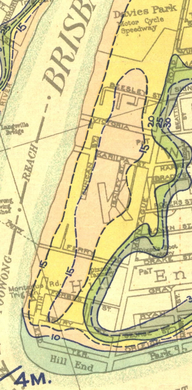
A long waterhole located between the river and Montague Road was known as “Kurilpa Swamp” and alternatively as “Coombe’s Swamp” in early days (see my post The Origins of Orleigh Park). Reeds from here were said to have been used to thatch the roof of South Brisbane’s first shop.
Image: The outline of the former Kurilpa swamp is visible in the flood contour of this 1933 map. (Queensland State Archive)
The swamp was a source of controversy for many years. The water requirements of local residents and market gardeners conflicted with increasing health concerns, as the body of water became polluted. An 1884 proposal to drain the swamp met with a petition from local land owners, citing their need to use the water for household use in dry periods.
Drainage work was completed in nearby Musgrave Street in 1889, where a small creek that flowed from the swamp across what is now Davies Park flowed into the river.
The plans for this work have survived and show the original water course, as well as the path of an earlier wooden drain.
Waterview Terrace on the plan is now known as Buchanan Street. Running water is visible looking down an access point in the street.
A few years ago during the construction of a residential tower here, pumps were working 24 hours a day with a continual flow of water into the river.


Concerns about the swamp continued to arise, and in 1896 an open drain down Kurilpa Street to reduce the depth of water was proposed.
In 1916, one nearby resident described the swamp as a “stinkpot and disease ridden inferno” and commented that “the water therein is covered with unhealthy looking green slime, which, to on amateur on sanitary science, looks bad and polluted”. He mentioned the recent death of his neighbour’s two children from typhoid fever. A 12 inch (30cm) pipe was run to the river in 1917, draining the swamp. At that time there was still a market garden using the water.
Walking along the riverside park today, some 14 storm water drains can be seen along this 1,300m section of the river, reflecting the amount of work that has been required over the years.
Image: Kurilpa Swamp based on the plan “Brisbane & Environs Sheet 1” of 1861 by James Warner. (Openstreetmap with detail added by P. Granville).
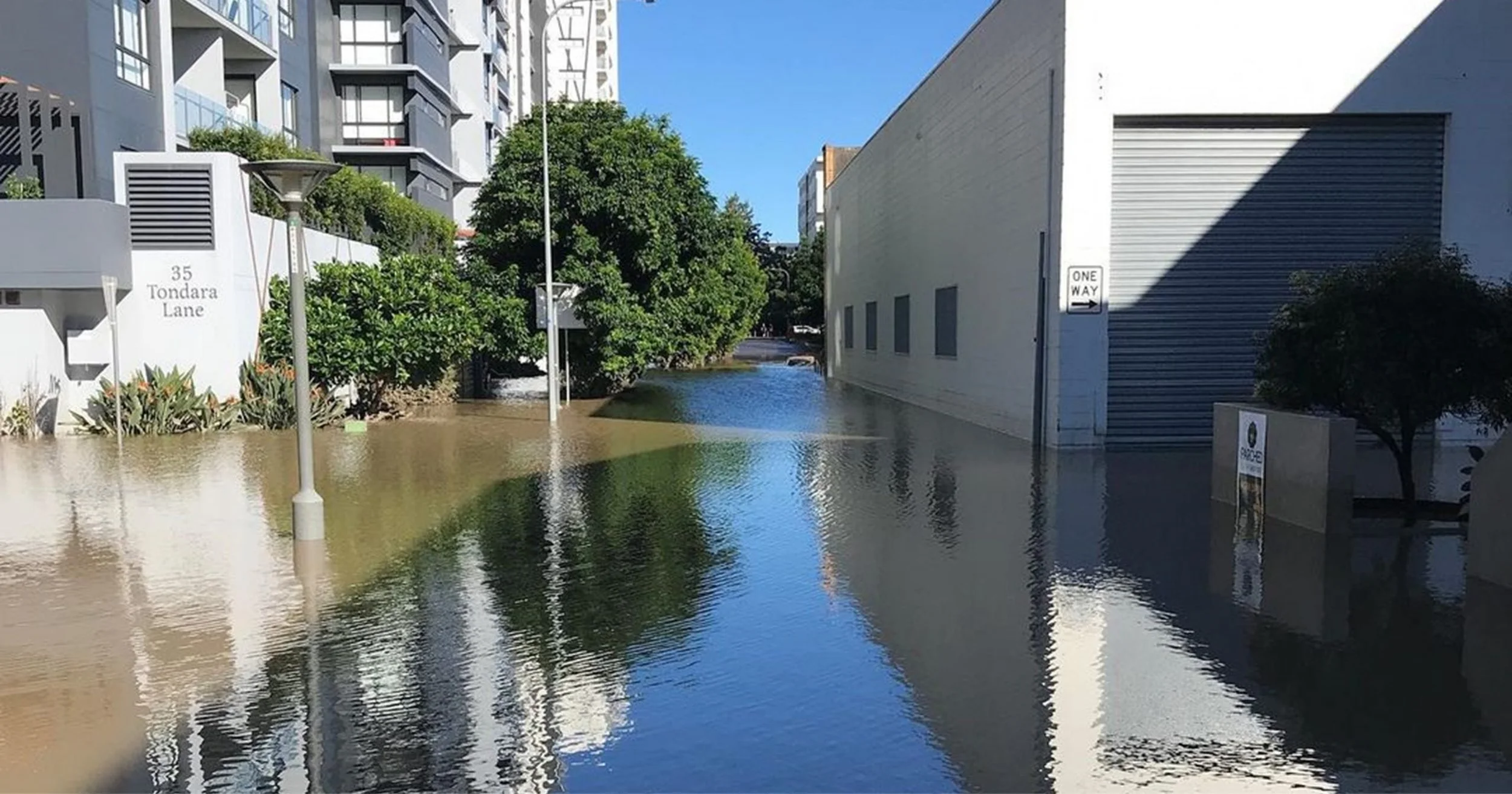
Image: Flooding in Rogers Street, February 2022. This is close to the point where a small creek flowed into Kurilpa Swamp. (Nic Skips).
Floods continue
Despite continual drainage work, we have been frequently reminded of the low lying nature of the land by the numerous floods that have occurred.
Some of the worst flooding has been in the low lying areas that were previously swamps, such as near the corner of Melbourne and Boundary Streets.
The images below are from the 1893 and 2011 floods, the corner of Boundary Street and Mollison Street looking towards the Boundary Hotel. They serve as reminders of the long swamp which ran along the south side of Melbourne Street.


The swamp extended down Merivale and Melbourne Street, ending in the South Brisbane creek. Images below show flooding from 1893, 1974 and 2011, looking down Melbourne Street.


Today this history of both too much and at the same time too little water is largely forgotten, except in times of heavy rain and flooding.
If you live in the area, check the map of watercourses and swamps (see first image). You might be surprised, or perhaps not!
Paul Granville is a historian and author of the blog Highgate Hill and Its History.


